r l i i
Si '1
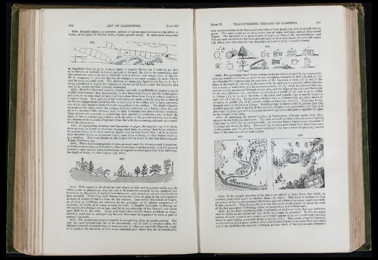
2330. Irre g u la r fig ure s, as parterres, outlines of picturesque plantations ( fig . 682.), or
water, or the plans of winding walks, require greater nicety. In such cases, temporai-y
or im^mary lines (a , b, c), fonning parts of regular figures (as d with b), are first
to be fonned, or partially indicated, around or through the plot to be transferred ; and
dimensions are next to be taken relatively to these known and simple lines or figures.
Of all temporary or skeleton figures, the triangle is the most simple, the most correct,
and the most generally used. The skeleton or temporary figure (c) or line (a , b, &c.)
being transferred to paper, the dimensions (d ) are set off from it, and the irregular plot
and all its details are thus correctly delineated.
2331. R a ise d o r depressed surfaces, whether naturally or artificially so, require a sort of
double measurement ; first, horizontally, by true horizontal lines, to get the surface-plan;
and next, to measure their elevations or depressions from these lines, in order to find their
lieight or depth. Few gardens of any description are made perfectly flat ; the borders of
the kitchen-departments generally rise on each side ofthe walks; and in large pai-ten-es,
one of the chief beauties arises from the inequalities of the surface. The depth of ponds,
excavations for dung, earth, &c. ; ridges, hotbeds, rockwork, even houses, trees, &c., are
ml to be measui-ed with reference both to thefr horizontal and perpendicular extension.
I oiir pertons are required in performing such operations accurately ; two to hold the
chain or hne in a horizontal position, or in the plane of the general surface ; one to take
the dimensions downwards or upwai’ds from this with the measuring-rod, and one to mark
down the dimensions.
2332. I n representing elevations and depressions on p ap er, the simplest way is to introduce
sections, in dotted or otherwise distinguished lines, to prevent their being mistaken
tor surface-Hncs ; or, in wavy surfaces, figures may be introduced, thus ^ or a, to denote
their elevation above, or depression below, some piece of water, or other sm-face fixed on
^ a medium. Numerous details on this subject will be found in our S e lf-In s tru c tio n fo r
Young Gardeners, See.
2333. W here it is in contemplation to fo rm pieces o f w ater, tbe elevations and depressions,
or levels, must be taken and recorded, either by sections or arithmetically, with the greatest
accm-acy ; and, in some eases, sections may be required to show particular trees, buildings
the depth of water, or other objects (fig . 683).
2334. W ith respect to the elevations an d shapes o f h ills and m ountains which may lie
withm parks or plantations, they are only to be measured correctly by the quadrant and
theodolite, in the hands of regular land-sm-veyors; and, therefore, are not considered as
here included. Their shape and dimensions are laid down in maps in the same manner
as those of smaller deviations from the flat surface. Inaccessible dimensions of height,
as of trees or buildings, are obtained by the quadrant, or by relative comparison of
shadows; of depth, as of water or wells, by rods; of breadth or length, by finding the
two angles of a triangle whose base shall be in one extremity of the distance, and whose
apex shall be in the other. These, and many other equally simple problems in trigonometry,
need not be eidarged on, because they must be supposed to foi-m a part of
general education.
2335. T h e greatest accuracy is requisite in tra n s fe irin g p la n s o f garden-scenery. Not
only the mere ground-lines arc to be transferred; but to form a complete plan, the
distances between scattered trees, or trees in rows or otherwise regularly disposed, ought
to be mai-kcd, the situations of their stems indicated, and, where they are of considerable
size, representations of the horizontal extension of their heads ( %. 684. i) should alste^
¿Y?. The same ought to he done in tho case of walls, hmldmgs, and all other rased
obiects. The intention of a ground-plan is to give an idea of the superstracture , and
without sneh additions to the mere ground-lines, as these and otocrs of a pictorial natme
, „ . • 1 _ a._T_________________________nt- In o c f 1T1 TllflTIR Al 1111X6(1
without such additions to tne mere gruuuu-uue», »0 ^
(fig . 684.); that idea must be very imperfect, at least m plans oi mixed scenery.
« a A
n
2336. F o r p o rtra y in g r u ra l objects vanous modes have been adopted hy land-surveyom
trees are sometimes shown by smaU crosses or ciphers, triangles or dots (/p 684 a) by
an orbiculate line representing the extension of the branches or head, and a dot in the
nlace ofthe trunk (b and d ) ; bythe same, with tho addition of a s h a d o w , taken when the
«in is south or south-west, and his elevation exactly 45°, hy which the points of the compass
are readily ascertained throughout tho plan, and the shape rf the *
of the tree exhibited ( e ) ; sometimes an elevation or profile of the tree is giren, cithei
H Maie f n or to show the form of the trunk and branches (p), or merely to give a
? d S a of i ’tree ? Hedge-rows, whether with or ivithont trees are either shown in
l t r a f e e it o e r f f it e f e ? ? f o S 7 “^BTdtogrm??
“ o t ? » « ? ? general surface o f land-estates, different modes have been
edited bv Xdeim la«d-surveyors. The first we shall mention is the old mode of giving
those of its contents and general outline.
685 686
2338. In the second, devatiorw o f E je c ts a r e t^ '^ ^ r é teT Îe tep Ito tb ?