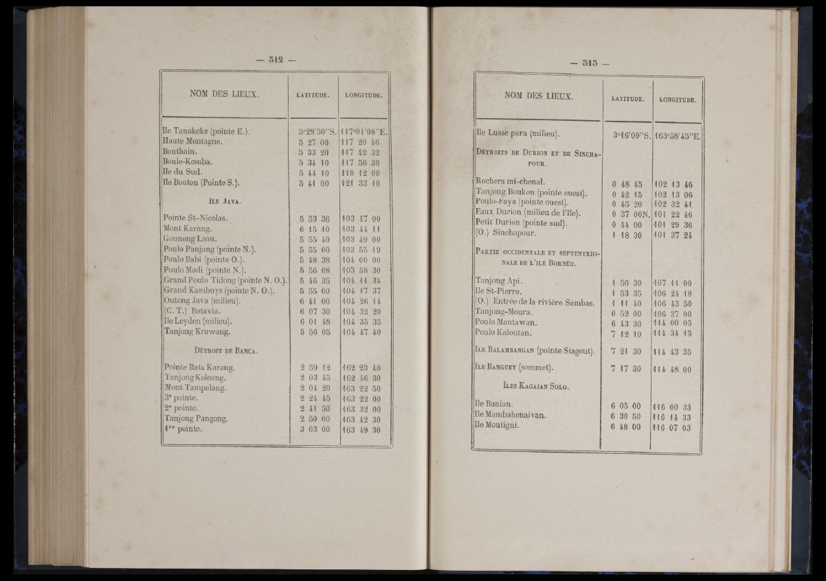
NOM DES LIEUX. LATITUDE. LONGITUDE.
Ile Tanakeke (pointe E.). 5°:29’50” S. 117®!01’08” E .
Haute Montagne. 5 27 00 1 1 7 20 46
Bonthain. 5 33 20 1 1 7 42 32
Boule-Komba. 5 34 10 1 1 7 56 30
Ile du Sud. 3 44 10 1 18 12 00
Ile Bouton (Pointe S.). 5 41 00 121 33 10
Il e J a v a .
Pointe St-Nico las. 5 S3 36 103 47 00
'Mont Ka rang. 6 13 10 103 44 11
Rounong Laou. 5 55 40 103 49 00
Poulo Panjang (pointe N.). 5 55 00 103 55 19
Poulo Babi (pointe 0 .) . 5 48 38 104 00 00
Poulo Madi (pointe N.). ô 56 08 103 58 30
Grand Poulo Tidong (pointe N. 0 .) . 5 46 35 104 11 34
Grand K amb uy s (pointe N . 0 . ). 5 53 00 104 17 37
Outong Java (milieu). 6 41 00 104 26 14
(C. T.) Ba ta v ia . 6 07 30 104 32 20
Ile Leyd en (milieu). 6 01 48 104 35 35
Tanjong K raw an g. 5 56 05 104 47 40
D é t r o it d e B a n c a .
Pointe Bats Karang. 2 39 12 162 23 40
Tanjong Koleang. 2 03 45 162 46 30
Mont Tampelang. 2 04 20 163 22 50
3® pointe. 2 24 45 163 22 00
2® pointe. 2 41 50 163 32 00
Tanjong Pangong. 2 50 00 163 42 30
1*'® pointe. 3 03 00 163 49 30
■ —1 1
NOM DES LIEUX. LATITUDE. LONGITUDE.
Ile Lusse p a ra (milieu). 3°16’00” S. 163°58’45” E .
D é t r o it s d e D ü r io n e t d e S in c h a -
POUR.
Bochers mi-chenal.
Tanjong Boukou (pointe ouest).
Poulo-Faya (pointe ouest).
F a u x Durion (milieu de File).
P e tit Durion (pointe sud).
(0.) Sinchapour.
0 48 43
0 42 15
0 45 20
0 37 OON.
0 44 00
1 18 30
102 13 46
102 13 06
102 32 41
101 22 46
101 29 36
101 37 24
P a r t ie o c c id e n t a l e e t s e p t e n t r io n
a l e DE l ’îl e B o r n é o .
Tanjong A p i.
Ile St-P ie r re .
(0.) Entrée de la r iv iè re Sambas.
Tanjong-Moura.
Poulo Mantawan.
Poulo Kaloutan.
1 56 30
1 53 35
1 11 40
0 52 00
6 43 30
7 12 10
107 11 00
106 24 10
106 43 50
106 37 00
1 14 00 05
1 14 34 15
I l e B a l a m b a n g a n (pointe Siagout). 7 21 30 1 14 43 35
I l e B a n g u e y (sommet). 7 1 7 30 1 1 4 48 00
Il e s K a g a ia n S o l o .
Ile Banian.
Ile Mambahenaivan.
Ile Moutigni.
6 05 00
6 30 50
6 48 00
1 16 00 33
1 16 14 33
1 16 07 03