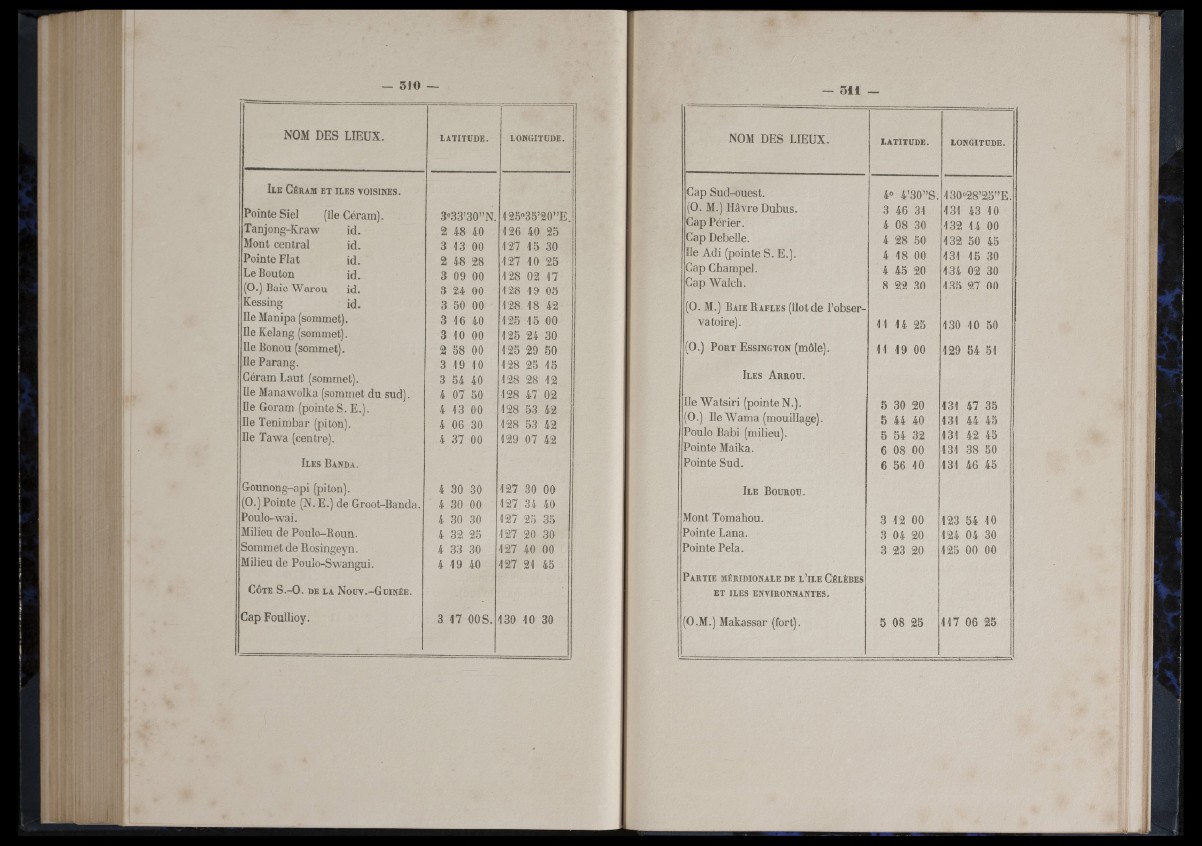
NOM DES LIEUX.
I l e Céram e t î l e s v o i s i n e s .
Pointe Siel (île Céram).
Tan jon g -K raw id.
Mont central id.
Pointe Fiat id.
Le Bouton id.
(0.) Baie W a ro u id.
Kessing ifi.
Ile Manipa (sommet).
Ile Kelang (sommet).
Ile Bonou (sommet).
Ile Parang.
Céram L au t (sommet).
Ile Manawolka (sommet du sud).
Ile Goram (pointe S. E.).
Ile Tenimb ar (piton).
Ile T aw a (centre).
Il e s B a n d a .
Gounong-api (piton).
(0.) Pointe (N. E.) de Groot-Banda
Poulo-wa i.
Milieu de Poulo-Boun.
Sommet de Bosingeyn.
Milieu de Poulo-Swangui.
Côte S .-O . d e la Noüv.-G u i n é e .
Cap Foullioy.
LATITUDE. LONGITUDE.
3°33’30” N.
2 48 40
3 13 00
2
3
3
3
3
3
48 28
09 00
24 00
50 00
16 40
10 00
2 58 00
3 19 10
3 54 40
4 07 50
4 13 00
4 06 30
4 37 00
4 30 30
4 30 00
4 30 30
4 32 25
4 33 30
4 19 40
125°35’20” E
126 40 25
12 7 15 30
12 7 10 25
128 02 1 7
128 19 05
128 18 42
12 5 15 00
12 5 24 30
12 5 29 50
128 25 15
128 28 12
128 47 02
128 53 42
128 53 42
129 07 42
12 7 30 00
12 7 34 40
12 7 25 35
12 7 20 30
12 7 40 00
12 7 21 45
3 1 7 OOS. 130 10 30
NOM DES LIEUX. LATITUDE. LONGITUDE.
Gap Sud-ouest. 4“ 4’30” S. 130“28’25” E.
(0. M.) Hâvre Dubus. 3 46 31 131 43 10
Gap Périe r . 4 08 30 132 14 00
Gap Debelle. 4 28 50 132 50 45
Ile A d i (pointe S. E.). 4 18 00 131 15 30
Cap Champel. 4 45 20 134 02 30
Cap Wa lch . 8 22 30 13 5 27 00
(0. M.) Baie B afles (îlot de l ’observatoire).
11 14 25 130 10 50
(0.) P o r t E s s i n g t o n (môle). 11 19 00 129 54 51
I l e s A r r o u .
Ile W a ts ir i (pointe N.). 5 30 20 131 47 35
(0.) Ile W am a (mouillage). 5 44 40 131 44 45
Poulo Babi (milieu). 5 54 32 131 42 45
Pointe Maika. 6 08 00 131 38 50
Pointe Sud. 6 56 10 131 46 45
Ile B o u r o u .
Mont Tomahou. 3 12 00 123 54 10
Pointe Lana. 3 04 20 124 04 30
Pointe Pela. 3 23 20 12 5 00 00
P a r t ie m é r id io n a l e d e l ’îl e Gé l è b e s
ET ILES ENVIRONNANTES.
(O.M.) Makassar (fort). 5 08 25 1 1 7 06 25