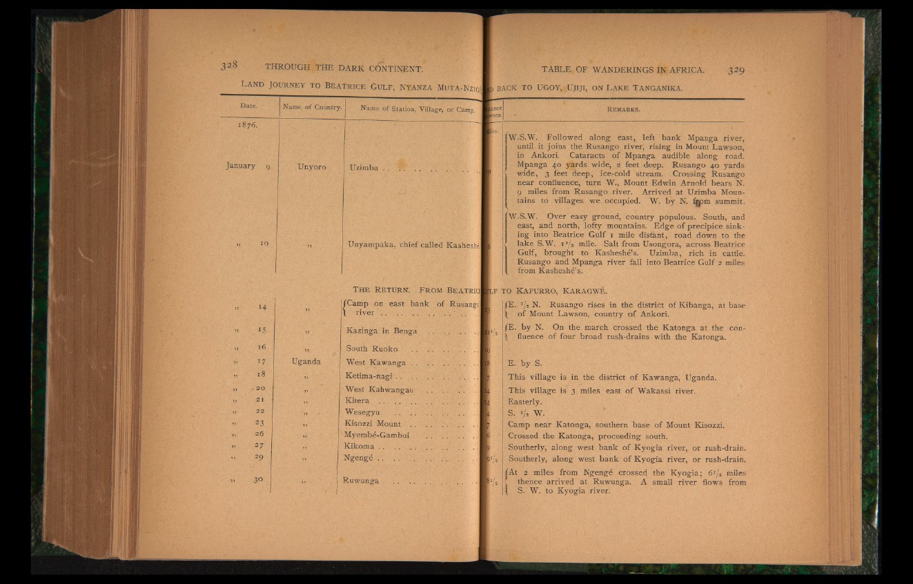
Date. Name, of Country. Name of Station, Village, or Camp.
VC
00
January 9 Unyoro Uzimba . .
„ to >> Unyampaka, chief called Kasheshé
14
i s
16
17
18
. 20
21
22
23
26
2 f
2 9
30
Uganda
T h e Re tu rn . F rom Beatrici
{Camp on east bank of Rusango!
river .. . . .. .. v . ‘ ... ...j
Kazinga in Benga
South Ruoko
West Kawanga . .
Ketima-nagi
West Kahwangau
K i t e r a ................
Wesegyu . . ..
Kisozzi Mount
Myembé-Gambui
Kikoma................
Ngengé . . ..
Ruwunga
R e m a r k s .
les.'
W.S.W. Followed along east, left bank Mpanga river,
until it joins the Rusango river, rising in Mount Lawson,
in Ankori. Cataracts of Mpanga audible along road.
Mpanga 40 yards wide, 2 feet deep. Rusango 40 yards
wide, 3 feet deep, ice-cold stream. Crossing Rusango
near confluence, turn W., Mount Edwin Arnold bears N.
9 miles from Rusango river. Arrived at Uzimba Mountains
to villages we occupied. W. by N. fgpm summit.
W.S.W. Over easy ground, country populous. South, and
east, and north, lofty mountains. Edge of precipice sinking
into Beatrice Gulf 1 mile distant, road down to the
lake S.W. i 1/* mile. Salt from Usongora, across Beatrice
Gulf, brought to Kasheshe’s. Uzimba, rich in cattle.
Rusango and Mpanga river fall into Beatrice Gulf 2 miles
from Kasheshe’s.
f,F TO KAFURRO, KARAGWÉ.
/E g » N Rusango rises in the district of Kibanga, at base
\ of Mount Lawson, country of Ankori.
JE. by N. On the march crossed the Katonga at the con-
J fluence of four broad rush-drains with the Katonga.
E. by S.
This village is in the district of Kawanga, Uganda.
I This village is 3 miles east of Wakassi river.
Easterly.
S. i/± W.
Camp near Katonga, southern base of Mount Kisozzi.
Crossed the Katonga, proceeding south.
Southerly, along west bank of Kyogia river, or rush-drain.
EU Southerly, along west bank of Kyogia river, or rush-drain.
fAt 2 miles from Ngengé crossed the Kyogia; 61/* miles
!11 < thence arrived at Ruwunga. A small river flows from
( S. W. to Kyogia river.