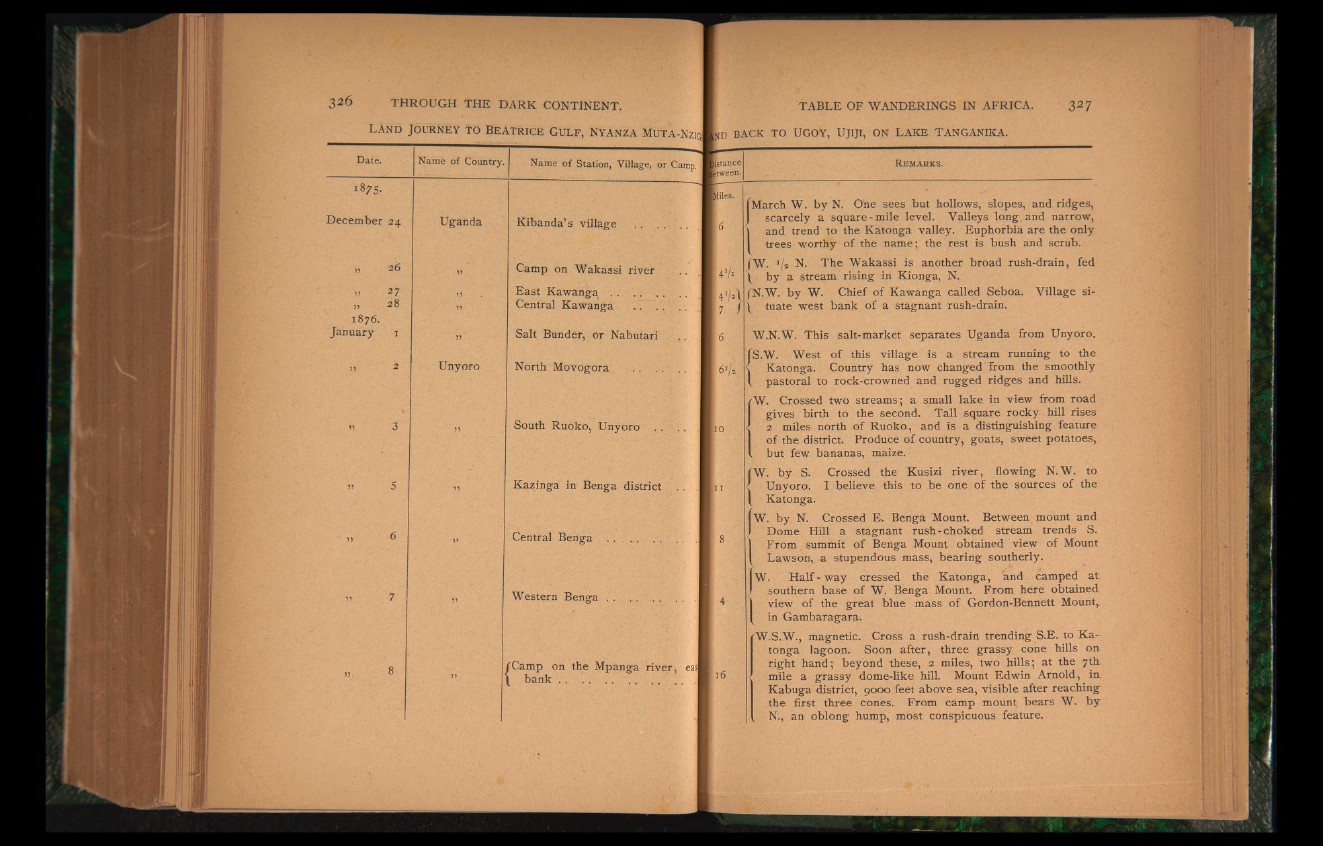
R e m a r k s .
March W. by N. O'ne sees but hollows, slopes, and ridges,
scarcely a square-mile level. Valleys long and narrow,
I and trend to the Katonga valley. Euphorbia are the only
trees worthy of the name; the rest is bush and scrub.
JW. */» N. The Wakassi is another broad rush-drain, fed
I by a stream rising in Kionga, N.
JN.W. by W. Chief of Kawanga called Seboa. Village sill
tuate west bank of a stagnant rush-drain.
W.N.W. This salt-market separates Uganda from Unyoro.
S.W. West of this village is a stream running to the
Katonga. Country has now changed from the smoothly
pastoral to rock-crowned and rugged ridges and hills.
W. Crossed two streams; a small lake in view from road
gives birth to the second. Tall square rocky hill rises
2 miles north of Ruoko, and is a distinguishing feature
of the district. Produce of country, goats, sweet potatoes,
. but few bananas, maize.
W- by S. Crossed the Kusizi river, flowing N.W. to
Unyoro. I believe this to be one of the sources of the
Katonga.
i W. by N. Grossed E. Benga Mount. Between mount and
Dome Hill a stagnant rush-choked stream trends S.
From summit of Benga Mount obtained view of Mount
Lawson, & stupendous mass, bearing southerly.
W. Half-way cressed the Katonga, and. camped at
southern base of W. Benga Mount. From here obtained
view of the great blue mass of Gordon-Bennett Mount,,
in Gambaragara.
W.S.W., magnetic. Cross a rush-drain trending S.E. to Katonga
lagoon. Soon after, three grassy cone hills on
right hand; beyond these, 2 miles, two hills; at the 7th
mile a grassy dome-like hill. Mount Edwin Arnold, in.
Kabuga district, 9000 feet above sea, visible after reaching
the first three cones. From camp mount bears W. by
, N., an oblong hump, most conspicuous feature.