Date.
1875.
March 8
10
h
13
14
15
16
17
19
23
2 4
N»me o f Country. Name o f Station, V illa g e , o r Camp,
T h e C i r c u m n a v i g a t i o n o f L a k e v i c t o | k, t h e e x p l o r i n g b o a t “ L a d y A l i c e .”
Usukuma
Ukerewé
Ururi
Ugeyeya
Ugana
Usoga
A P P R O X IM A T E
Kagehyi to Igusa
Natwari Island 2 .
t a n c e
w e e n .
R e m a r k s .
¡24
End of Speke Gulf
Kitaro Island 11 I 13° /
Kiregi Island ................ .. H 2g
Irangara
Shizu Island
Bird Islands
P 5
Burdett Coutts Island
Dobo Islands ..
Mouth of Mori river
Ugeyeya
¡30
35
Bridge Island .. .. .. H 30
Pike Island
Manyara
Muiwanda
pJCES SAILED.
[les.
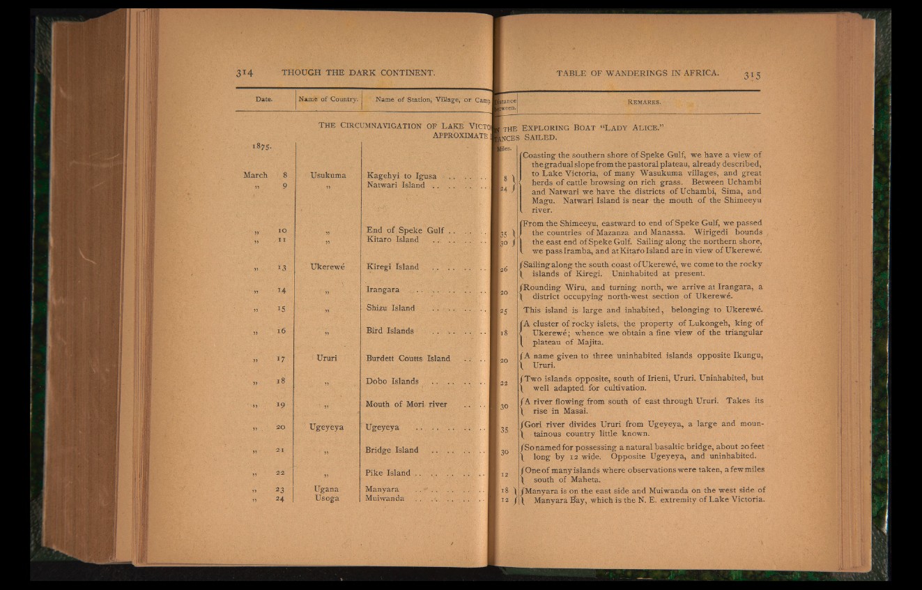
f Coasting the southern shore of Speke Gulf, we have a view of
the gradual slope from the pastoral plateau, already described,
to Lake Victoria, of many Wasukuma villages, and great
herds of cattle browsing on rich grass. Between Uchambi
and Natwari we have the districts of Uchambi, Sima, and
Magu. Natwari Island is near the mouth of the Shimeeyu
. river.
From the Shimeeyu, eastward to end of Speke Gulf, we passed
the countries of Mazanza and Manassa. Wirigedi bounds
the east end of Speke Gulf. Sailing along the northern shore,
I we pass Iramba, and atKitafo Island are in view of Ukerewe.
/Sailing along the south coast of Ukerewe, we come to the rocky
\ islands of Kiregi. Uninhabited at present.
/Rounding Wiru, and turning north, we arrive at Irangara, a
\ district occupying north-west section of Ukerewe.
This island is large and inhabited, belonging to Ukerewe.
A cluster of rocky islets, the property of Lukongeh, king of
Ukerewe; whence we obtain a fine view of the triangular
plateau of Majita.
rA name given to three uninhabited islands opposite Ikungu,
L Ururi.
/Two islands opposite, south of Irieni, Ururi. Uninhabited, but
\ well adapted for cultivation.
/A river flowing from south of east through Ururi. Takes its
\ rise in Masai.
/Gori river divides Ururi from Ugeyeya, a large and moun-
/ tainous country little known.
/So named for possessing a natural basaltic bridge, about 20 feet
\ long by 12 wide. Opposite Ugeyeya, and uninhabited.
/One of many islands where observations were taken, a few miles
/ south of Maheta.
18 / /Manyara is on the east side and Muiwanda on the west side of
: J2 /I/ Manyara Hay, which is the N. E. extremity of Lake Victoria.