IC
' I
h (ìli
5 AP P E N D I X .
BEAGLE'S CHAIN OF MERIDIAN DISTANCES AND RESULTING
LONGITUDES ID the Atlaatic Ocean.
1S31—1886.
Monte Video to Port Desire
Port Desire to Port Famine
Port Famine to Port Louis
Port Louis to Cape Horn
Bahia to Ascension ...
Ascension to St. Helena
St. Helena to Simon's Bay
Simon's Bay to the Observatory at the Cape
of Good Hope
o 38
0 20
o 61
0 38
1 38
48,0
10,7
22,0
35,2
26,7
0 34 45,7
1 36 33,3
o 00 10,9
OTHER DETERMINATIONS.
Beagle in 1829—Monte Video to Port Desire
Beagle in 1830—Port Desire to Monte Video ...
Adventure (tender)—Port Desire to Port Louis
Adventure (tender)—Port Louis to Port Famine
And, therefore, Port Desire to Port Famine
Captain King's published result of all the measures made between
1828 and 1830 places Port Famine west of Monte
Video ...
The present result, as above stated, is
Beagle in 1830—Cape Horn to Port Desire, by three short
steps with interveningrates ...
Which would place Cape Horn in longitude ...
Beagle in 1832—Direct from Monte Video, made
Captain Foster's meridian distance from Monte Video to St.
Martin Cove, reduced to Cape Horn, and used with the
Beagle's longitude of Monte Video, gives the longitude ...
H, M. s.
4 2 3 40,8
4 4 3 51,5
3 5 2 2 9 , 5
4 29 04,7
0 57 37,1
0 22 51,4
1 13 41,9
1 13 52,8
0 3 8 47,7
0 38 45,9
0 31 n , o
0 51 21,9
0 20 10,9
0 5 8 58,1
0 5 8 58,7
0 0 5 33,7
4 29 04,5
4 2 9 08
4 2 9 04
0 3 4 46,8
0 3 4 48,3
1 3 6 45,7
1 3 6 45,0
1 13 53,2
1 13 56. S
1 1 3 55,0
Coquille, M. Duperrey—St. Helena to Ascension ...
Captain Foster—St. Helena to Ascension
Captain Foster—St. Helena to the Cape Observatory ' ...
Nautical Almanac—St. Helena to the Cape Observatory
Mr. Fallows, 1828—Cape Observatory
Mr. Henderson, 1832—Cape Observatory
Mr. Maelear, l836~-Cape Observatory
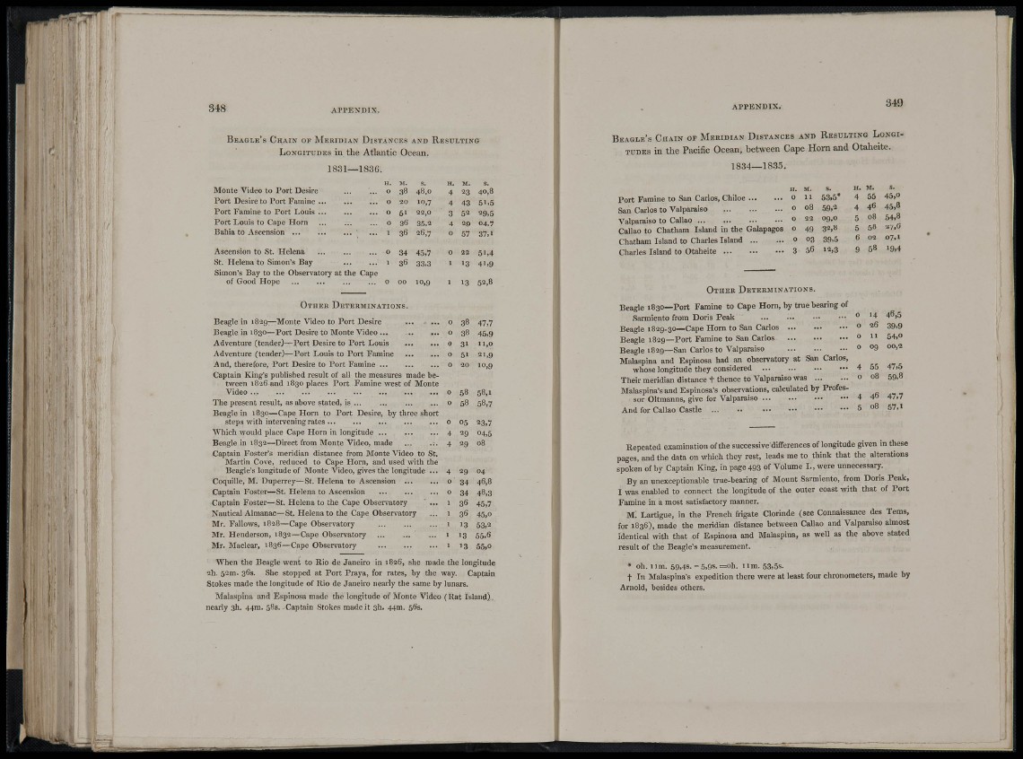
When the Beagle went to Rio de Janeiro in 1826, she made the longitude
2h. 52m. 36s. She stopped at Port Praya, for rates, by the way. Captain
Stokes made the longitiide of Rio de Janeiro nearly the same by lunars.
Malaspina and Espinosa made tile longitude of Monte Video (Rat Island),
nearly 3h. 44ra. sBs. Captain Stokes made it 3h. 44m. 56s.
APPENDIX. 349
BEAGLE'S CHAIN or MERIDIAN DISTANCES AND RESULTING LONGITUDES
in the Pacific Ocean, between Cape Horn and Otaheite.
1834—1835.
Port Famine to San Carlos, Chiloe ...
San Carlos to Valparaiso
Valparaiso to Callao
Callao to Chatham Island in the
Chatham Island to Charles Island ...
Charles Island to Otaheite
H. M. s. H. M. s.
0 11 53,5* 4 5 5 4 5 , 0
0 08 59.2 4 46 4 5 , 8
0 22 09.0 5 08 5 4 , 8
0 4 9 32,8 5 5 8 27,6
0 03 39,5 6 02 07,1
3 56 12,3 9 58 19,4
OTHER DETERMINATIONS.
Beagle 1830—Port Famine to Cape Horn, by true bearing of
Sarmiento from Doris Peak
Beagle 1829-30—Cape Horn to San Carlos
Beagle 1829—Port Famine to San Carlos
Beagle 1829—San Carlos to Valparaiso
Malaspina and Espinosa had an observatory at San Carlos,
whose longitude they considered
Their meridian distance t thence to Valparaiso was
Malaspina's and Espinosa's observations, calculated by Professor
Oltmanns, give for Valparaiso
And for Callao Castle ...
0 14 4 6 , 5
0 26 39,9
0 1 1 54,0
0 09 00,3
4 5 5 4 7 , 5
0 08 59,8
4 46 4 7 . 7
5 08 5 7 , 1
Repeated examination of the successive differences of longitude given in these
pages, and the data on which they rest, leads me to think that the alterations
spoken of by Captain King, in page 493 of Volume I., were unnecessary.
By an unexceptionable true-bearing of Mount Sarmiento, from Doris Peak,
I was enabled to connect the longitude of the outer coast with that of Port
Famine in a most satisfactory manner.
M. Lartigue, in the French frigate Clorinde (see Connaissance des Terns,
for 1838), made the meridian distance between Callao and Valparaiso almost
identical with that of Espinosa and Malaspina, as well as the above stated
result of the Beagle's measurement.
• oh. l lm. 59,4s. -o,9s .=oh. 11m. 53,5s.
t In Malaspina's expedition there were at least four chronometers, made by
Arnold, besides others.