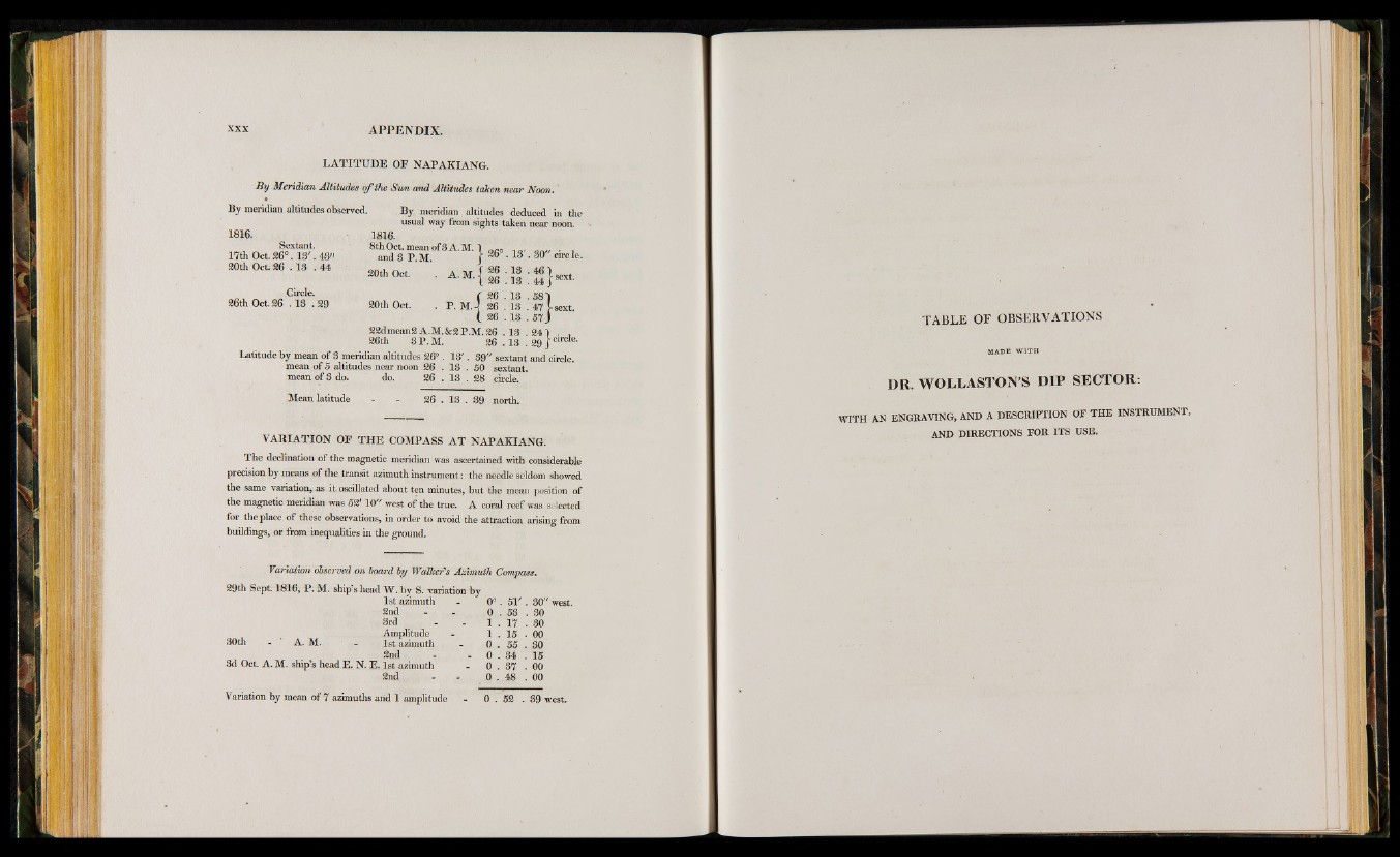
LA T ITU D E OF NAPAKIANG.
B y Meridian Altitudes o f the S u n and Altitudes taken near Noon.
By meridian altitudes observed. By meridian altitudes deduced in the
usual way from sights taken near noon.
1816.
8t^ 1 S . ° f 3A-M- } ^ . l 3' . S 0" c ir cle.
20th Oct. . A . M . { | ; ^ ; 4 6 j sext
f 26 . 13 . 581
20th Oct. . P. M.-I 26 . 13 . 47 J-sext.
(. 26 .1 3 . 5 7 )
22dmean2 A.M.&2P.M. 26 .1 3 .2 4 ) . ,
26th 3 P .M . 26 . 13 . 29 J circfe-
Latitude by mean of 3 meridian altitudes 26° . 1 3 '. 39" sextant and circle,
mean of 5 altitudes near noon 26 . 13 . 50 sextant,
mean of 3 do. do. 26 . 13 . 28 circle.
Mean latitude - - 26 . 18 . 39 north.
VARIATION OP T H E COMPASS A T NAPAKIANG.
The declination of the magnetic meridian was ascertained with considerable
precision by means of the transit azimuth instrument: the needle seldom showed
the same variation, as it oscillated about ten minutes, but the mean position of
the magnetic meridian was 52' 10" west of the true. A coral reef was selected
for the place of these observations, in order to avoid the attraction arising from
buildings, or from inequalities in the ground.
Variation observed on boa/rd by Walker's Azimuth Compass.
29th Sept. 1816, P . M. ship s head W . by S. variation by
1st azimuth - 0 ° . 5 1 '. 80" west.
2nd - - 0 . 53 . 80
3rd - - 1 . 17 . 80
Amplitude - 1 . 15 . 00
30th - A. M. - 1st azimuth - 0 . 55 . 30
2nd - - 0 . 34 . 15
3d Oct A. M. ship’s head E. N. E. 1st azimuth - 0 . 37 . 00
2nd - - 0 . 48 . 00
1816.
Sextant.
17th Oct.26°. 13 '. 43"
20th Oct 26 . 13 .4 4
Circle.
26th Oct. 26 .1 3 . 29
Variation by mean of 7 azimuths and 1 amplitude 0 . 52 . 39 west.
TABLE OF OBSERVATIONS
M A D E W I T H
DR. WOLLASTON’S D IP SEC TO R .
WITH AN ENGRAVING, AND A DESCRIPTION OF THE INSTRUMENT,
AND DIRECTIONS FOR ITS USE.