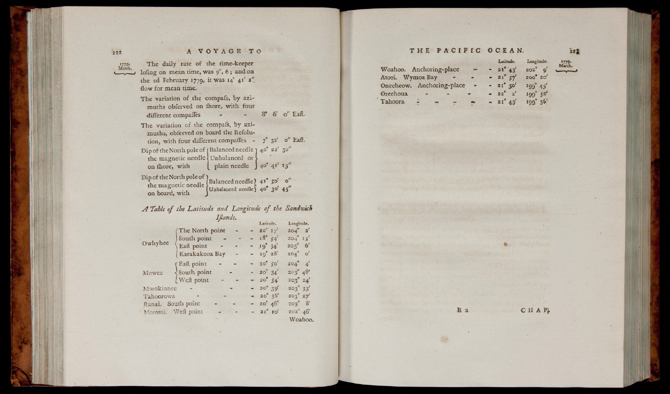
l779;
March.
S ' 6 ’ a " Eat-
T h e da ily rate o f the time-keeper
lo fin g on mean time, was 9", 6 ; and on
the 2d February 1779, it was i4k 41' 1 "
t o w fo r mean time.
T h e variation o f the compafs, b y a z imuths
obferved on ihore, w ith fo u r
■different compafles
T h e variation o f the compafs, b y azim
uths, obferved on board the Refolu-
tion, w ith fo u r different compaffes - 7
'D ip o f th eN o r th p o leo f f Balanced needle t 40° 22' 30"
the magnetic needle i Unbalanced or >
on Ihore, w ith [ plain needle J 4°° 4 1 ' 15"
D ip o f ,h eN o r th p o k o f jM a n c e d n i : r f l . ^
the magnetic needle I ^
on board, w ith J
A Table of the Latitude and Longitude o f the Sandwich
IJlands
E a t.
O w h yh e e
Mowee
fT h e North point
) South point -
\ Eaft point
! Karakakooa Bay
r Eaft point
•j South point
(W e ft point
Morokinnee
Tahoorowa
Ranai. South point
Morotoi. ’Weft point
Latitude.
20° 17'
18° s d
19 34'
i 9* 28'
20* SO'
20° 34'
20* 54'
20° 3 9 '
20° 38'
20° 46°
21° I o'
Longitude.
204* 2
204° IS
20 5° 6
204° o
204° 4
203° 48
203° 24
203° 33
203° 27
203° 8
202° 46'
Woahoo.
Latitude. Longitude*
Woahoo. Anchoring-place — - 21° 43' 202° 9'
Atooi. Wymoa Bay - - - 21° 37* 200* 20'
Oneeheow. A nchorin g-place - - 2 1' 50' 199° 45'
Oreehoua - - - - 22° 2' 199° 52?
T ah o ora - ■* r f - 21° 43' 199° 36'
*