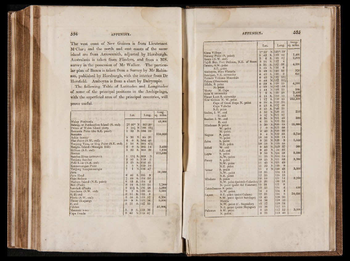
The west coast of New Guinea is froirr Lieutenant
JVPClur; and the north and east coasts of the sanrer
island are from Arrowsmith, adjusted by Horsburgh.
Australasia is taken from Flinders, and from a MS.
survey in the possession of Mr Walker. The particular
plan of Banca is taken from a Survey by Mr Robinson,
published by Horsburgh, with the interior from Dr
Horsfield. Amboyna is from a chart by Dalrymple.
j The following Table of Latitudes and Longitudes'
of some of the principal positions in the Archipelago,
with the superficial area of the principal countries, will
prove useful.
Lat.' Long.
Geog.
sq. miles.
Malay Peninsula 48,000
Salang, or Juhkceylon Island (S. end) 79 469 N 98 ? 20'
Prince of Wales Island (fort) 5 244 N. 100 214
Romania Point (the S.E. point) 1 22 N. 104 16
Sumatra 130,000
Achin (town)* 5 36 N. 95 26
Flat Point (S.Vf. end)' a 0 S. 104 40
Tanjong Tora, or Hog Point (S.E. end) 5 54 S. 105 434
Bangka Island (Monopin Hill) 2 0 s. 105 14 3,400
Billiton (S.E. end) 3 22 s. 108 20 1,600
Borneo 212,500
Sambas River (entrance) 1 13| s. 109 3 Tanjong Sambar 2 58 s. 110 8
Pulo Laut (N.E. end) 3 23 s.- 116 41
Konneroongan Point 1 5 s.. IQ9 10
Tanjong Sampanmangio 7 1 N. 106 47 ' Java &OC1 . 50,000 Java Head 6 46 s. 105 9
Cape Sedano 7 49 s. 114 28
Madura Island (N.E. point) 6 53 s. 114 2
Bali (Peak) 8 24 s. 115 24 1,700
Lombok (Peak) 8 214 s.' 116 26 1,900
Sambawa (S.W. end) 9 2 s. 116 45 3,600
S. E. end 8 51 s. 119 8
Floris (S.W. end) 8 55 s. 119 57 6,300
Timor (Kupang) 10 9 s. 123 36 9,000
E. end 8 21 s. 127 15
Celebes si 55,000
Macassar town 5 .9 s. 119 36
Cape Donda 0 48 N. 119 ô 7
Kima Village
Butung Point (S. point)
CBaojoerloi B(Nay.W, F. oernt dD) efence, N.E. of Booro
Ceram, S. W. point
S.E.point
Amboÿna, Fort Victoria
Batcbian, S.E. extremity
Ternate Volcano Mountain
Tidore (Mountain)
Gilolo, S. point
N. point
Morty N. Cape
Aroo S. extremity
Timor Laut S. extremity
New Guinea N. W. point
Cape of Good Hope N. point
Cape Valsche
S.E. point
Sooloo, I. W. end
E. end
Basilan I. W. end
E. end
Mindanao S. point
W. point
N. point.
Negros 8N. .p opionitnt
Zebu S. point
N.E. point
Bohol WS..E e. nednd
Lèÿte SN. .pWoin. tpoint
Panay S. point
N.W. point
N.E. point
Samar 8- point’
N.W. point
N.E. point
Mindoro SN. .pWoi.n pt oint (pointde Cali
N. point (point del Escarseo)
Catandreanes S. point
N.W. point.
Luzon SS..EW. .p opionitn t ((ppooinint tC Saalanatina)go)
Mamla
N.W. point (C. Bogeador)
N.E. point (point Majsgue)
Pâlawan S".NW. n. opinot i.n. t
Lat. Long!
Geog.
sq. miles.
1 ? 22' N. 1259 19'
5 42 s. 123 44 1,40(.
3 6 S. 125 57 2,800
3 24 s. 127 4
3 31 s. 127 56 4,300
3 45 s. 131 0
3 40 s. 128 15 37c
0 48 s. 128 3 6o( ,
0 48 N. 127 131
0 40 N. 127 m 0 50 S. 128 25 4,500
2 23 N. 127 50
2 44 N. 128 25 900
7 6 S. 135 20 3,400
8 15 S. 132 15 1,600
1 27 S. 130 45 213,300
0 20 s. 132 31
8 23 s. 137 50
8 45 s. 148 25
5 52 N. 120 51 250
5 57 N. 121 27 6 34 N. 121 46 300 6 33 N. 122 22
5 30 N. 125 15 25,000
7 0 N. 121 50
9 49 N. 125 22
9 4 N. 122 53 2,750
10 58 N. 123 13
9 26 N. 123 3 1,550
10 58 N. 123 55
9 53 N. 123 37 ' 900
9 48 N. L24 22
9 50 N. 124 59 2,800
11 33 N. 124 15
10 25 N. 121 59 3,300
11 43 N. 121 49
11 33 N. 123 9
11 2 N. 125 43 3,800
12 33 124 15
12 33 125 13
12 10 121 14 2,700
13 26 120 18
13 31 121 0
13 13 124 4 450
14 4 124 4
12 31 124 5 30,600
13 45 120 38
14 36 120 58
18 27 120 34
18 36 122 15
8 23 117 12 3,80e
8 28 119 40