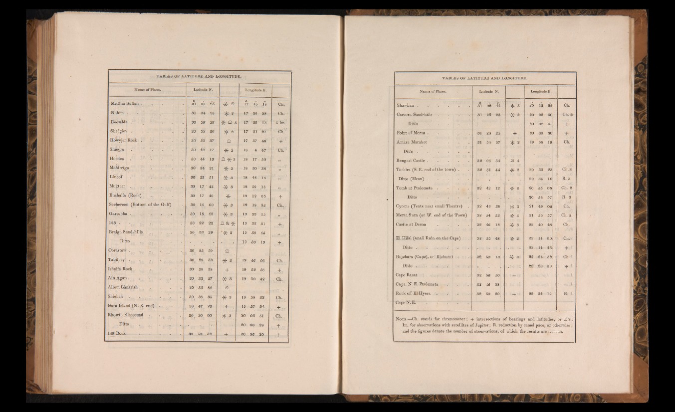
TABLES OF LATITUDE AND LONGITUDE.
Names of Places. Latitude N. Longitude E.
Medina Sultan.. 31 07 25 * a 17 15 18 Ch, ■
Nahim . . . . . 31 04 23 4; 2 17 26 58, Gh.
Boos aida / 30 59 39 * a s 17 39 1:5 5 ÎmV
Shedgàn . • . . . . 30 55 30 i); a 17 51 27' ^ Chi • :
HoWyjer Rock . . . . 30 55 37 ■ a 17 57 46 ‘ ‘"-f"1 |
Shegga : . 30 49 17 * 2 18 4 47 Ch. I
Hoodea . . 30 44' 13 a * 3 18 17 55 „
Mahirriga . . . ' . 30 34 21 * 3 18 30 38 . ^ ;
LinOof . 1 v . . . 30 23 51 * 3 18 44 18 j .:
Muktarr . . , . ... . . . 30 17 43 * 3 18 59 .18 » •
Bushaifa (Rock) 30 17 40 * f 19 12 ° 5, +
Seckereen (Bottom qf:the Gulf) 30 16 00 * 3 19 18 33 Ch, !
Gartubba , .. ... . . . . : 30 18. 48 * 8 19 32 15
123 • . . . . 30 22 22 a & * 19 32 31 . +;
Braiga Sand-hills. . . . . 30 23 39 ”* 2 . 19 39 45 ir .
Ditto ■ .. . 19 39 19 ■
Oorartow . , v . . . . 30 25 59 4 .
Tabilbey: > . 1. r T„ f ■ _ 30 28 53 * Sm 19 46 06 Ci?-
' Ishaifa Rock . ., . . . 30 36 18 + 19 52 56 . .+<-
AinAgan . . 30 33, 57 * 3 19 50 42 • Cb.
. Allum Limàrish . ., 30 35 88 a
: Shiebah ., . 30 f 38 35
* 3 19 58 23 .Ch...
: Gara. Island (N. E. end) . 30t 47 20 + . 19 57 24. + •
Rhowte Elassouad . , • . ... . 30 r 50 00 ïfc 3 20 05 51 . Ck. r
. Ditto . . . . 20 06 28 +
149 Rock . . . 30 53 32
+
20 Û6 20 +
TABLES OF LATITUDE AND LONGITUDE.
Names of Places. . Latitude N. Longitude E.
Shawhan.. . . . i . E . à
31 02 44 * 3 20 18 26 Ch.
Carcora Sand-hills 31 26 23 * 2 20 02 50: Ch. 2
Ditto . . . . . 20 02 45! +
Point of Mersa . . . . 31 28 25 ,+ - 20 00 30; +
Amara Marabot . . . . 31 54 57 * 2 19 58 19 Ch.
Ditto . . . . . .
Beugazi Castle . . . . . 32 06 54: Q. 4
Tochira (S. E. end of the town) . 32 31 44 *- 2 20 33 23; Ch. 2
Ditto (Mean).................................... 20 34 10 R. 3
Tomb at Ptolemeta . . . . 32 42 12 -X- 2 20 55 08 Ch. 2
Ditto . • . . . 20 54 57; . R. 3
Cyrene (Tents near small Theatre) 32 49 38 * 3 21 49 05 Ch.
Mersa Suza (or W. end of the Town) 32 54 53; * 4 21 55 57 Ch. 2
Castle at Derna . . . 32 46 18 ■* 3 22 40 48 Ch.
El Hilkl (small Ruin on the Cape) ! 32 55 48; 0 2 22! 11 001 Ch^
Ditto .; ......... . 22; .11. 45: • ■#!
Bujebara (Gape), or Ejeburni : 32. 53 .13: * 3 22: 24: 52; : : Gb.l
Ditto i. . I . . .; 22 23 30i ; + \
Cape Rasat . . . . . . • 32. 56 501 j -
Cape, N. E. Ptolemeta . . . 32 46 38,
Rock off El: Hy era . . . . .. 32. 50 20 j 22 34 12- I R. 1
Cape N. E. . . . .
Note.—Ch. stands for chronometer;' + intersections of bearings and latitudes, or Z ’s ;
Im. for observations with satellites of Jupiter; R. reduction by camel pace, or otherwise ;
and the figures denote the number of observations, of which the results are a mean.