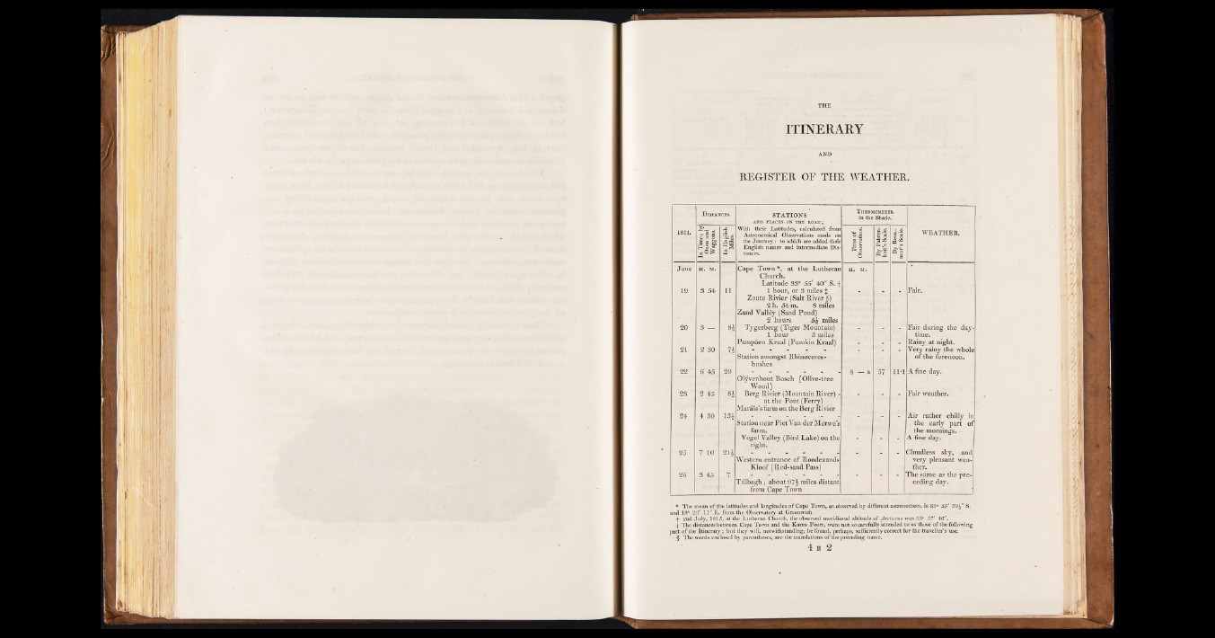
ITINERARY
AND
REGISTER OF THE WEATHER.
D istances. STATIONS
Th ermometer
in the Shade.
1811.
In Time ; by
Oxen and
Wdggons.
In English
Miles.
With their Latitudes, calculated from
Astronomical Observations made on
the Journey: to which are added their
English names and intermediate Distances.
Urne of 1 Observation.
I By Fahrenheit’s
Scale.
J|
« ss
WEATHER.
June H. M. Cape Town*, at the Lutheran
Church.
Latitude 83° 55' 40“ S. f
H. M.
119 3 54 h 1 hour, or 3 miles £
Zoute Rivier (Salt River $)
2 h. 54 m. 8 miles
Zand Valley (Sand Pond)
2 hours 5£ miles
Fair.
20 3 — 8* Tygerberg (Tiger Mountain)
1 hour 3 miles
Pamp6en Kraal (Pumkin Kraal)
Fair during the daytime.
Rainy at night.
21 2 30 . n
Station amongst Rhinoceros-
bushes
Very rainy the whole
or the forenoon.
22 6 45 20
Olyvenhout Bosch (Olive-tree
Wood)
8 —a 57 11*1 A fine day.
28 2 45 84 Berg Rivier (Mountain River) -
at the Pont (Ferry)
Marius’s farm on the Berg Rivier
Fair weather.
24 4 30 134
Station near Piet Van der Merwe’s
farm.
Vogel Valley (Bird Lake) on the
right.
Air rather chilly in
. the early part of
the mornings. -
A fine day.
25 7 10 214
Western entrance of Roodezands
Kloof (Red-sand Pass)
Cloudless sky, and
very pleasant weather.
26 3 45
7 Tulbagh; about 97i miles distant
from Cape Town
The same as the preceding
day.
» The mean of the latitudes and longitudes o f Cape Town, as observed by different astronomers, is 33° 55' 59 J" S.
and 18° 23' 11" E . from the Observatory at Greenwich.
•f- 2nd July, 1815, at the Lutheran Church, the observed meridional altitude o f ¿¡returns was S5° 57' 46".
| The distances between Cape Town and the Karro Poort, were not so carefully attended to as those of the following
part o f the Itinerary; but they will, notwithstanding, be found, perhaps, sufficiently correct for the traveller’s use.
§ The words enclosed by parentheses, are the translations o f die preceding name.