A T L A S OF AUSTRALIA—1886.
W/in-/.—Tlie Gilbert Eivor issues ft'oin the Dividing Chain, its
upper basin being boimded ou the south by the Greifory ]{ange.
its numerous triljuiary streams may be montioned the Eiiuishigh,
CoppnrjMd, El-hnruiyr:, aud Rohcrt^n Rivers. The Newcastle
Range forma the waterslii.il between the Einasleigh on the one side,
and the Ktheridge and Gilbert on the other. This river forms anahes
inches in ita course, aud res
1, copper, and load a
the coast by sovenil months. Goid,
Î found on the north-eastern slope of
the Gregory Kanjje.
Numian.—The Norman River collects its waters on the southwestern
side of the G regory Range, aud is one of the finest streams on
the Northern watei-shed. Its average width, for a distance of 15 miles
from its mouth, is about half b mi le. A bar, which shoals to a depth of
from 4 to 7 feet at low water, lying about 3 miles off the shore, obstructs
its outrance, but within the river, large vessels can easily be navigated
to the Baffle Group, about -W miles from the sea. Here occur immerouB
sand-banks, which prevent vessels, escept those of very light
draught, from proceeding fai-ther. The lower part of the course is
remarkable for its numerous windings. At it« embouchure the shore
is low, aud covered with a dense growth of mangroves. Its principa]
afflueuts are Walker'e Creek, Carrón Rívflr or Cjyoí Craeíf, Chtrína
Creek, and the Yappar Riirr.
Flindirs.—Tho Flinders River has its principal source in the
Dividing Chain, immediately south of the Gregory Kiinge. Its np]>eibn.
çin is bounded on the south by the high downs which mark the
culminating line of this portion of the tableland. As it issues from
the mountains, its course has » general direction to the west ; it
subsequently flows north, 'nie Cloiw.un-ij Eiver, its most import.int
tributary, receives its waters fi-om the Selwyn and McKinlay Sangos,
over 300 miles west from tho source of the main stream. The following
affluent« augment the volume of the Flinders :—The Sa.cby, ll'ootg'ir,
and DuUoii Rivers, and Siewiirt, BelU Gurge, Forcu/nne, Walker's,
O'Conncll, and Ncelia Creeks. The Clonciirry Biver receives the
waters of Dimal Creek, Dugald Bict-r, Corella Cretk, WUtiamg Rivei-,
Fulhirlmi or Marehml River, (iilliat River, McKirilatj Rinr, Eastern
Creek, and Julia Creek. Part of its upper basin consists of immense
plains, with rich soil, and well grassed tiiroughoat. As it approaches
the head of the Gulf, tho Flinders divides into two stieams, tho northeiistem
one being known as the S.jnoe River. Near the source of the
Cloncurry is an extensive gold-field. Co|)pei', iron, lead, aud bismuth
are also found in the surrounding country.
PwtMmwl Creek is a small stream flowing north into Jlorniníf
Inlet.
Lcichhardl.—Ths waters of tho Leichhardt River issue from the
Selwyn Rauge, and have a general direction to the north, reaching
the Gulf of Carpentaria at Kangaroo Point. The principal tributaries
of this stream are, the Ali^tandra or Landsborough Ricer on it.s right
bank, and Gicnpotcder, Myally, Mitligoody, Fiery or Biwie Bierie
rcodbine, and .miar's Creek»,
n its left bank. At its r uth a
found extensive flats covered wi
.-Jiieri.—The volnme of the Albert River is maintained, to some
extent, by au overflow from the (rregory River, which by means of
on effluent channel reaches the former. Near its embouchure, the
land is flat and marshy, and covered with a dense growth of mangroves.
GTegory.-Thh river receives a large portion of its waters from
the northern slope of Barkiay Tableland. It has a genera! direction
to the uorth-north-east, reaching tlie coast at Pascoe's Inlet. North
of the lS)th parallel, its course leads through richly grassed plains
imd open country, well suited to pasturing sheep and cattle. Its
principal aiBuent, the NichoUoii River, rises in the Northern Territoiy
of South Australia, and flows east. The following tributaiy streams
add to its waters : — R i v e r , .Irchie. Creek, South Esk
or Luwn Jlill Greek, and Elknhellt Creek.
Mooidighl, ClifdaU, Lmjoo», and Selthmeut Credit are small
unimportant streams which have their origin in iome swampy plains
extending north from the left bank of the Nicholson l{i\-ei'.
SocTH-w>:sT Slopk.—
Tho fall towards the colonies of New South Wales aud South
Australia is of a very gradnal nature, and presents few features
to interrupt the general flow of the rivers to the south-west. It«
limit, on the oast, is the culminating line of the DiWding Chain, and
on the north, the westerly extension of the (ireat Tableland, which
skirts almost the entire seaboard of Australia, a short distance inland
therefrom. On reference to a map, it will at once be seen that the
slope to the south-west consi.sts of three principal basins. The fii'st
of tbese includes the
in New South Wales;
and the third, the streams flowi
Cooper's Creek, in Houtli Austi-a
^rs which converge towards the Dariing,
3 second, those that reach Lake Bullno ;
J into, and
. The volli
1 the direction of,
le of many of the
rivers of this watershed is of a very uncertain character, When
di-oughts occur, little romains to be seen, in some places, but dry
beds. At other times, after continued and heavy rainfaU, floods
are not uncommon.
Geonjiiw.—'[:h\a river has its principal source in Barklay Tableland,
and receives iunin and Rankin's Greeks from South Australia.
Numerous tributaries add to its volume—prinoipaJly on its left bank,
Tlie following may be enumerated :—Buckley River, Mingara, or Qidga
Creek, Trmphton River, Moonuh Creek, Si. Roiiun's Creek, and Smoky
Creek. Much of the country watered by these streams consists of
open downs, lightly timbered, aud, in many places, well grassed.
Burke River issues from the Selwyn Eange. Its principal tributaries
are the Snlicmon aud irt7?s Creeks. Kirb/s Range gives rise
to the HamilUm River.
Diamunlina or Mueller.—This stream takes its rise on the western
face of the Sword Range, and in the upper part of its course forms a
large semicircle. After receiving tho waters of the We.'itani Rivin-, it
has a general direction to the south-west. Oti its banks, in some
parts, sandstone ranges aro found to alternate with well-grassed open
downs. Ridges covered with spinifes, and mulga and giddia scrub,
occur in other places. The plains are marked with numerous channels,
and south of the 2oth parallel, the water spreads over their surface,
giving rise to dense polygonum scrubs. The principal affluents are
Wokingham Creek, Milb Creek, IfMÍer» River, Mayne Rivn- or Binhm
Creek, Farrnr's Creek, MMktou- Creek, and Muckunda. Greek.
Thomson.—Ihe Thomson River has a south-westerly direction, and
shows a defined coui-se to Cooper's Creek. In the upper basin of this
river, west from Lake Jochmiis, there are open well-graased downs,
irith belts of brigalow and boree. Much of tho country drained is of
a superior character for the pasturing of flocks and herds. Its
principal affluents are, Pniirie, Bullock, Torren's, Towerhill, Landsborough,
Ouriiish, Arnmac, Rodney, Katherine, Achen'on, and Ven/emont
Creeks, and the Darr Rivei-.
J3íirtüü.—The waters of the Barcoo River are collected by the
J)i\-iding Chain, aud the Wan-ego, Cheviot, Grey, Canaway, Coleman,
and McGregor's Ranges. Its more prominent afflueuts are the Alice
and WiUoii Rivers, Jordan, Diimal, Domjlas Fonds, Birkhefd, Ravenshourne,
Thoriileigh, PoiveU's, Kyahra, and Irani/ TIW^ Creaks.
Immense tracts of flooded coniiti-y ave met with on various parts of
the lower course of the Barcoo after heavy rains. This is usually
the case where the channels are shallow and undefined. During
floods in tho Thomson and Bareoo Rivers, the waters are backed up
the Kyabra Crook, and, overflowing their banks on the east side of
the Canaway Rauge, run south over the plains through Congie Gap
into the Wilson River.
jBttZio».—The Bulloo River ends in a lake of the same name,
situated near the south-western extremity of the colony. After heavy
and continued rainfall, the lake forms an immense sheet of water of
about 200 square miles iji extent, with a depth of from 12 to 1.5 feet.
When full, an overflow takes place on its southern margin. The
Biilloo rises in a spur from the main chain, its basin being sepai-ated
fiom that of the Bai-coo by a south-westerly extension of the same
range. Along tho banks of tliis stream are extensive plains suitable
for pastoral pui'poses. Its chief tributaries are Blaekwater, Gumhardo,
WtuUn, and Goomhu Gooinho Creeks.
Fnroo.—The Paroo River flows tow.u'ds the Darling, but its waters
seldom reach that stream. This result is largely due to three causes:
1st. The arid character of the country through which it flows; 2nd.
The small average i-ainfall throughout its basin ; aud 3rd, The
extensive evaporation which obtains. The chief affluents are Beehel,
YiiKiih, and Mimiparoo Creeks.
irajTfj/o.—'I'he Warrego is another stream which directs its cour.'^e
towards the Darling Ifiver. Its sources lie in tho Great Dividing
Range, immediately south of Buokland's Tableland, and some of
them !iro found issuing ft'om the Warrego Range, Tho genei-.il
direction of this river is a little to the west of south. Low spurs and
short detached ranges, connected by ridges sufficiently elevated to
detennine the flow of streams, sepai'ate its basin Eiom that of tho
Paroo on the west, and the Nebio or Nebine Creek on the ea.«t.
lixcept during floods, it consists, to a large extent, of a series of
I'eaches and water-holes. Tho more im])ortaut tributaries are, the
Langlo, Ward, and Nice Rivr^, aud Doolnogurlk, JTogmilhulla, and
Angdlaln Créais.
The Nellie or NMne, MwujalMo, and Wallnm Gireks are unimpoi'tant
watercourses. Their upper basins do not reach so far uortli
as tho slopes of the Dividing Chain, and thoir flow, except nftor
heavy rainfall, is of an intermittent character. Their direction is
towards the Culgoa River, but their watei-s become lost in tho plains
before reaching that stream. In many places, tho courses aie
undefined, and little more than shallow channels.
Q U E E N S L A N D .
Jl/»r„.,,o„.-The Maranoa River issues from the Dividing Chain, a
httle to tlie south of tho 2ath parallel. Its valley is partly bouudo.l
on the >rest by a low spur which separates it from that of the Wan'ej
River. It has a genera! direction to tho south, but after crossing t l -
27th parallel, turns to the south-east, and adds its waters to tl
Ualoiine River. Its affluents are, Merivah, BHUH, Manadilla, Worn.
Ul/'t, and Amhy Creeks.
Condamine.-1'he Condatnine, a stream of some importance, risi
m the Dmdmg Range, near the southern boundary of the colon"
and immo.liately after issuing from tho mountains. Hows to the uorti,-
west. It subsequently turns to the west, aud afterwards to the southwest.
Herries Range forms the boundary of its basin for a consider
able distance on the south-west. It maintains a position parallel
to the mam cham for a largo portion of its couree. The followin.^
tributaries add to its Tolnme GUngalUn, Dahymple, Einn'.
S"d9^>'^i',Oaky,Myall,Jivihoxw,Ooorangah,CharUy'e,Dofpvood Yuleht-
Wallambilla, Bungil, Yalelmne. Muekadilia, and Tarlulia Creeks, on itnght
bank, and TluLnes, Canal, Wilkin's, Wamlo, Undidla mrilh
and Donga Creeks, on its left bank. A^ its watere approach thnorthern
boundary of the colony of New South Wales, under thname
of the Balonne River, they become divided into 'three mai).
streams, caUed the CuU/oa, Birie, and Narran Rivers,
to form effluents is here very marked. Farther south, the Birio
rise to the Bokhm'a Rivirr.
Moonie.—This river has its souree in a spur from th,
Low ridges separate its waters from those of the Condamine on thf
north and west, and the Weir, on the south and east. Among it?
affluents may be mentioned Fincl,es, ToombiU, Parrie Moolan, WonaU'
Wangle, Bardwell, and TeeOm Creeks.
The Weir River flows south-west, aud adds its watei-s to the
Barwon. Cattk, Wester,^, Booroondoo, Ura^wra, and
Minnel Creeks are its principal tributaries. Other streams approach
it, but become lost in the plains before a junction has been effected.
Barieoii or Macintirre.—The sources of this stream are situated on
the western face of the Great Dividing Rauge, within the colony of
New South Wales. For a considerable part of its course, it forms the
southern boundary of Queensland. Its more important affluents are
Macinlyre Brook, and the Dmnaresq or Severn River. The Barwon
forms two large ana-branches before it enters New South Wales.
These are kno;vTi as the Callandoim and the Boom.
separate course for a distance of over 70 miles.
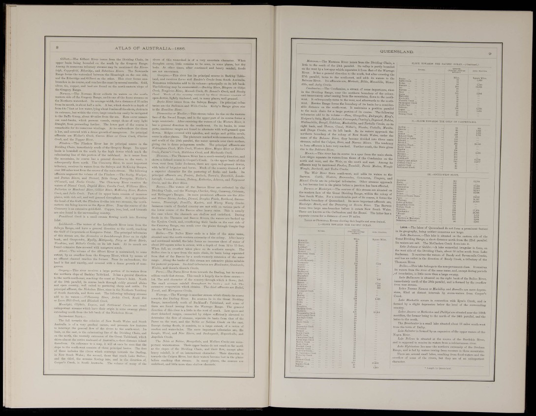
SLOl'K TOWARDS THE PACIFIC C
K CAKPESTAlttA.
n chain
The latter has a
•K Pn: VBUS sliomng tlicir Iciifrtlis
I—SLOPE rOWAED.S THE PACIFIC Oi
IS dmiucd.
• s a g '
Jt
B V 10 ?
I I C
Lak88,—The lakes of Queensl.
in its geography, being neither n
La.ke This lake is
.nd do not form a prominent feature
imerous nor large,
situated on the eastern side of the
Range, a short distauc
. - north from the 22nd parallel.
Its waters are salt. The McClashen Creek flo;vs into it.
Lake Jnchmus or Qalilee.—A lake somewhat irregular in form, on
the west side of the Dividing Chain, about -50 miles south from Lake
res tho waters of Dandy and Soven-mile Creeks,
the direction of Reedy Creek, a tributary of the
H<«l<ii. Oiw:k ..
Buchanan,
and has an outlet
Thomson River.
B'dloo.—This lake belongs to the non-permanont class. It receives
its waters from the river of the same name, and, except during periods
.of inundation, is little more than a large swamp.
Lake Bullawara is situated on the right bank of the Bulloo River,
immediately north of the 28th parallel, and is f ome d by the overflow
from that stream.
Lukes Vamma Yamma
sions, filled at distant
Creek.
or Mackillop :
intervals by
Lake Machattie occun
formed by a slight depri
country.
nd Barrolka aro mei
átorm-waters from
•depre
connection with Kyre's Creek, and is
in below the level of the surrounding
Laltes Amaroo or Eatherton and Phillipi- are situated near the 13ftth
meridian, the former being to the north of the 24t!i parallel, and the
o the south.
The Broadwater is a small lake aitnatod about IC miles soutli-west
from the town of Dalby.
L-ikc Salvator is formed by an expansion of the upper waters of the
Nogoa River.
Trfife Pelicim is situated at the source of the Burdekiu River,
and is supposed to receive its waters from a subterranean river.
Lake ElpUnstone lies near the northern extremity of the Dcnham
Rauge, and is fed by -waters issuing from recesses in these mountains.
'I'liere are several small lakes, resulting from Hood-waters aud the
jvei'flow of s
îharacter.
of the , but thev > of f D important
• r.cnirtli in QIIM:I,|.