• J „i
>li I
B
ATLAS OF AUSTRALIA—1886.
HAMILTON.—Hamilton, tht> capital of tho western district,
is situfttod on tlie Urange IBuru, a tributary of the 'Vrannon River,
aud derivos its iiuportnnce from tlie fact tliat it forms tlie ohiaf
enlrep'jt for the produce of a vei-y ki^e esteuC of country. The
laud is occupied for pastoral purposes. CultivatioD of the soil is
atti'iapted, but it receives less attentiun than sheep-farming. Mount
Pievi'epoint, which lies about 3 miles tu the south-east, readies an elevation
of 028 feet above tiie level of the sea. To the south of Lake
Keuiu'dy are numerous swamps and mnrshes. The town contains some
very fine substantial buildings. It possesses a hospital, benevolent
asylum, mechanics' insditute, and other institutions of a pubhc
character. Tho railway lino to Castsrton and Portland passes through
it, and provides means of communicatiou with the metropolis. The
annual rainfall varies between ¿5 and 8.5 mchos. Population, 2,9(37.
H A P P Y VALLEY.—A mining township near the right bank
of the Woady Taloak Creek, about 20 miles south-west from
Ballarat. Po])ulation of neighbourhood, 563.
HARCOURT.—On Barker's Creek, a small tributary of the
Loddon River, about -5 miles north-east from Castlemaine. The
adjoining country is occupied chiefly for dairy-fanning and agriciiltui
e. Various fruits grow well in tho neighbourhood. Moimt
Alexander, which lies about 2 miles to the east, is of gi-anite
formation in its ba
for building and otl
line to Echuca, aud
the level of the sea.
H A R R O W . — J
Kivar, about 50 miles
country is almost ent
rainfall varies betweeu
H A S T I N G S . —
about -to miles south-so
This stone is quai-ried, and lai
ii-poses. Haroourt is situated on the railway
ele% ation of about 1,100 feet above
Popuktion, 183.
township on the right bank of the Glenelg
north-west ft'om Hamilton. The surrounding
irely upied for pastoral purposes. The
) inches annually. Population, 237.
1 the western shore of Western Port,
it froi rno. Fishing forms the
principal industry of the locality, large supplies beiug forwarded to
Melboui'ne. Fruit-growing is followed by some of the -lettlei-a. Populat
1, 300.
HAVELOCK.—_V small town near the left
mile Creek, and about miles east from the Bet
distant about 0 miles in a noith-north-east din
borough, being on the i-ailway line to St,
ik of the Fourt
Creek. It is
.n from Maiy-
I and Donald.
s of the district, and a considerable
amount of settlement has taken place in connection with cultivation
of the soU. Population, 265.
H A W K E S D A L E . — O n Tea Tree Creek, about 20 miles
noi-th from Belfast. The country around is very densely
aud occupied, for the most jmrt, for grazing purposes,
south a few miles, are found extensive twcts of Bat mai
known as the Moyne and Wild Dog Swamps, Population,
H E A L E S V I L L B . — A township on the 'V\'atts River, £
bered.
a tributary
Melboui-ne.
of the Yarra YaiTa, about 34 miles east-north-east
Much of the countn- is of a mountainous character,
by spurs from the Dividing Chain, The settlers
engaged in
farming, grazing, and cutting timber. In the immediate vicinity
is an extensive reserve for the use of the remaining aboriginals.
Population, 207.
HEATHCOTE.—Heathoote is situated on Mclvor-s Creek, the
waters of which flow into the Campaspe Itiver, and is distant about
28 miles east-south-eas
Gold-lield was well knc
n past yeai-s Iclvt
jud yielded a large
Jigs are estimated to covei
e reefs are known.
V engaged in the culti'
f the prec
ly of the
of the soil, the principal
which is of a straggling
Mount Ida. Population,
of Spring iiiid Jim Crow
products being wheat and
character, lies in a valley, near the foot
1,20.?.
H E P B U R N . — N e a r the junction
Creeks, tributaries of the Loddon Rivev
Daylesford.
estimated at
iriferous country :
it 88 quartz reefs
is said to contain medicinal pro])erties of a high order. The
extensively grown. Population, 300.
H E X H A M . - A township on the Hopk-ins River, about 31
north-north-east from Warmarnbool, and situated in the m:
country largely devoted to pastoral purposes. Population, 141
HEYPlEIiD.—i.iii the Thomson Kiver, about 18 mile;
north-west from Sale. Much of the laud in the «cinity ha
settled upon, and large areas are under cultivation. Sheep-f
engages a considerable amount of att^
A branch r
Traralgon, on the Gippsland line, ci
t with the
Population. 231.
ilwav
HEYWOOB.—Sitiintc'd on the Fitzroy River, about 15 miles
north from Portland. A considerable amount of settlement has taken
place in the neighbourhood, tho laud beiug principally occu])ied for
fai-ming and grazing puiposes. The native forests in the vicinity
su])ply material for the employment of saveral sa^nuills. The
railway line from the raeti-opolis to Portland passes through it.
Population, 1S3.
H I G H T O N . — A toAvnship in a valley near the Ba.-won River,
about 3 miles south-west from Geelong. The sun'ounding country,
which is of a hilly character, and very fei-tile, is occupied for
agricultural and grazing purposes. There are numerous gardens, and
large quantities of fi-uit are grown. The Barrabool Hills, in the
vicinity, add much to the beauty of the situation. Population, 244.
H I L L S B O R O U G H . - S i t u a t e d near the source of the Thilingalanga
Creek, about 9 miles east-south-east from Beechworth.
Auriferous quartz reefs occur in the district, and are worked with
remunerative results. The country generally is of a mountainous
character, and some very good views are obtained from several of
the summits in the vicinity. Population, 131.
H O C K K I R C H . — A to^vnship between tho Grange Burn and
Muddy Creek, about 5 miles from Hamilton. The residents of this
settlement are chiefly Germans; cultivation of the soil is the leading
industry of the neighbourhood. Population, 215.
HOMEBUSH.—A township situated between Bet Bet Creek
and the Avoca River, about 12 miles west from Maryborough. Much
of the country around is auriferous in character, some of the gi'ound
being exceptionally rich. The railway line to Avoca passes a short
distance to tho south of it. Population, 457.
HORSHAM.—Horsham, the principal town in the Wimmera
District, is situated on the right bank of the Wimmera River, near
the junction -with it of Burnt Creek, and lies about 42 miles northwest
itt a straight line from Stawell, To the north are found immense
plains, which extend, with but little inteiTuption, to the banks of the
Murray. Settlement is progressing in this direction, and land is
becoming occupied for pastoral purposes. South, towards the
Grampian Mountains, the country is fairly watered, part of it
beiug under cultivation, and part devoted to grazing. Several
manufacturing industries have arisen in and around the town. There
are flour-mills, foundries, a brewery and
• of fine substantial buildings, and Botanical
: 37 acres. It is supplied by
ine to Diniboola passes thi'ough
The ra
I, 1,644.
all V ÍS between 1 • and 2 inches
possesses a numb
Gardens which oi
water ft'om the ri-\
the town, and com
heat is fi'equently
is mild and pleasa
annually. Populai
HUNTLY.—Near the right bank of the Bendigo Creek, about
8 mile.s north-north-east from Sandhurst. The principal industry
in the neighbourhood is gold-mining, the workings being of an
alluvial character. Settlement has takeu place in various parts of
the district, and considerable areas are placed under cultivation, the
chief products being wheat, oats, and barley. Climate and soO suit
the vine, and tobacco and olives ore grown. The railway line to
Echuca passes a short distance to the east of the town. Population,
670.
INGLEWOOD.—Inglewood is situated about 4 miles from the
left bank of the Loddon River, and is distant about 30 nifles northwest
fi'om Sandhui-st. The impoi-tance of this town is largely due to
tho immense mineral resources in the immediate vicinitj-. Gold i-s
found, chiefly in connection with quart«. Numerous reefs have been
discovered, and mining and the reduction of the stone furnish
employment to a large number of persons. The surrounding settlors
jngaged, for the
the piinciiial product.
it pai
I N V E R L E I G H . — n
a junctio:
Much of tl > land 1 tho
of the
linfall varios between 15 and 25 iuclios
dry, the heat during su miner, being
The railway lino to Wycheproof and
lulatioB, 1,200.
the right bank of the Yarrowce River,
•won, about 18 miles west fi'om Geelong.
Ubourhood is of a fei'tile ehamcter, and is
.tiled I agricultural and gi'a purposes.
ctioi with it of the Jan
Much of the sur:
Population. 304.
J A M I E S O N . — A n
Goulburn River, at the jui
18 miles south fi'om Mam
of h mountainous character, and a large portion of it has been proved
to bo highly auriferous. Many of the reefs are vei-y rich, and have
yielded largo quantities of gold. About 20 miles to tho east, rise thf
])eaks of theGreat Dividing Bange,amid the nnmerons spurs from which
are collected the waters of the Jamieson liivor, Poijulation, 328.
VICTORIA.
J A N JUC. small township on
Spring Creek, about 1-t miles souch-Pouthfrom
Geelong. Much of the land is of a
flat character, and is occupied for agricultural
and grazing purposes, Population, 250.
J E R I C H O . - Near tho source of tho
Jordan Creek, a tributary of the Thomson
River, about 5 miles south from Wood's Point.
The country around is of a very mountainous
character, culminating, immediately Co the
north, in the peaks of the Great Dividing
Rango. About 5 miles to the north-west.
Mount Matlock roaches an elevation of 4,.561
feet above the level of the sea, while about. l.'>
iouth, rise the summits which are grouped
The
•/. reefs a
of the (.
Towi
E E B . A N G . - On th
jimction with it of Pyr!
from Echuca, Settleme
extending. Ai-eas of c
cultivation, but drought
yeai-s, in convoying prod
to retard pi-ogrt
Loddon River, a short distance
id Creek, about 58 miles west-north-west
in tJiis portion of the plains is rapidly
siderable extent have been placed under
and Che difficulty experienced, in past
to the consuming centimes, have done much
A short distance west from the to^-n, the plains
belts of mallee sci-ub. The rainfall varies
illy. The climate is very dry, and
mer, Ker
d t h i
between 8 and 2(
extremely hot du
metropolis by i-ailway line. Popu
K E W E L L . toivn on the
north-east from Horsham. It li
southern margin of tho groat mall
are occupied for pastoral and agrii
oast from Wodonga, Tho sui
is of a mountainous chai-acter,
purposes. Poijulation, 160.
KILMORE.—Kilmore i
of the same name, a tributarj
of rapidly increasing importa
Melbourne, with which it is coi
passing about 2 miles to the i
undulating in character, much
which is of volcanic origli
potatoes. Several manu
larriambiack Creek, about 20 miles
iS at no great distance from the
e scrubs. The surrounding plains
iiltural purposes. Population, 488.
iver, about 15 miles south-southnection
with gold-mining,
tho ragged and almost impassable ch
much to retard tho development of these diggings.
X A N G A R O O PLAT.—A mining town, ne
Bendigo Creek, about 3 miles south-south-west from Sandhurst.
Sandhurst connects it with the metropolis. It possesses an elevati
the level of the sea. Population, 1,109.
K E I L O R . - O u the Salt Water River, about II miles north-^
The plains in the vicinity are largely devoted to grazing pui-poses.
soil is earned on in the district, the principal product being hay.
Echuca passes about 3 miles west of the town. Population, 237,
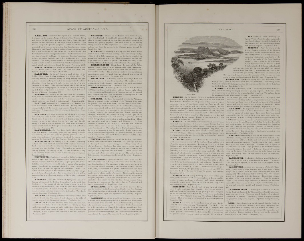
rise the cone-shaped peaks known as Tower Hill
elevations are but thinly timbered, and, in sc
The island has been reserved from sale o
beauty, aud will be retained for purpose
possesses several good substantial buildings.
KYNETON.—.Vn important toivn c
about 21 miles south-east from Castlem
country is extensively settled upon. Large
undor cultivation, the chief products being
and potatoes. It forms the eiUrepCl for the !
a district of considerable extent. Several
1, The slopes of these
places.
f ita T
of i-ecreatio Kor
Population, 1,6.14.
the Campaspo River,
ne. The suri'ounding
ireas have been placed
heat, oats, barley, hay,
ie of grain and stock for
anufacturing industries
dmg c .try, ^^-hieh ii
3upied for agricultural and pastoral
is situated near the source of the creek
y of the Goulburn River, and is a town
iuce. It lies about 39 miles north from
nnected by railway, tho line to Wodonga
east of it. The surrounding country is
of the land being very fertile. The soil,
iroduces large oi'ops of wheat, oats, aud
nills.
b fact Kvnetou lies at a ation of 1,087 feet above
pleasiiut and healthy climatc.
mo good substantial buildings
Castlemaine connects it «-itli
: of the western branch of the
ind well grassed, lly
i have thi
neighbourhood. There are flouiMnills, a tannery,
About 10 miles to the oast aro the Heedy Creek Gold-field:
some of the quartz reefs are notiid for their richness. Dairy-farmiuf
is ciirried on to some extant in the disti'kt, and sales of stock taki
substantial buildings, and elevation of
above tho level of the sea, i
aulat 1,092.
i healthy ,
several good
fer 900 feet
id pleasant.
K I N G O W E R . - A mining to^vn8hip on a creek of the same
name, about 8 miles west-south-west from Inglewood, The surrounding
coiintry is largely auriferous in character, and contains numerous
gold-bearing quartz reefs. Much of the laud is now occupied for
agricultural purposes. Population, 285.
KINGSTON.—Near the loft hank of the Bullarook Creek,
about 5 miles north-east from Croswick. The country around is
highlyauriferous.andhasyieldedalargequantityof gold. Kingston
lies on the northern slope of Forest Hill, aud possesses an elevation
of 1,-00 feet above the level of the sea. The climate is healthy and
pleasant. Much of tho land is now occupied for agricultui
Populatii
K O R O I T . -
lity is of a very f.
rops of potatoes,
ud possesses mu
il purposes.
>wn on the northern shore of Lake Koroit,
•west from Warrnambool. The land in the
rtile character, much of the soil being of a rich
I extensively cultivated, and produces immense
scenery connected with the lake is picturesque,
1 charm Wsitors and tourists. In tlie middle,
the level of the sea, and possesses
Tho streets are well laid out, and
adorn the town. The railway lino
the meti'opolis. Population, 3,062.
L A L LAL.—Near the right bi
Moorarbool River, about 13 miles
country around, which is fertile <
occupied for grazing pui-poses. Tlie diggings in the vicinity contain
both quartz and alluvial workings. Extensive beds of lignite or
" brown coal" are found. Large quantities of fire-wood aro cut in the
adjacent forests, and forwarded to Ballarat. Deposits of ironstone
occur on the Ijanks of the Jloorarbool. a few miles distant from the
town. The railway line to Ballarat connects it mth the metropolis.
Population, 281.
LAMPLOUGH,—t tn Rutherford's Creek, a small tributary of
the Avoca Rivev, about 4 miles souch-east from Avoca. The settlei-s
in the locality are engaged, for the most part, in grazing and mining.
Population, 100.
L A N C E P I E L D . — A tovvn near the source of the Salt Water
Rivei', a short distance south fi-om tho base of the Great Dividing
Range. It is distant about -15 miles north-north-west from Melbourne,
with which it is connected by railway line. The country
around is well known for its fertile character. The principal product«
ai-e wheat, barley, oats, potatoes, and chicory. From the extensive
forests in the vicinity, large quantities of firewood are obtained.
Lancefield is situated at an elevation of 1,561 feet above the level of
the sea, and possesses a genial- and pleasant climate. Population,
400.
LANDSBOROUGH.—A to^vnship
Station Creek, a tributary of the Wimmera
agricultural and pastoral p
branch of the Heifer
about 20 miles westveral
diggings of an alluvial
•y around is largely occupied
Population of neighbourhood.
LARA.—Lara, situated near the left bank of Hovell's Creek,
o the railway lino between Melbourne and Geelong, being abont 35
iiles distant from the former, and 9 miles from the latter. Th
ountry around, which is well grassed, is occupied for agriculture an
airy-fanning. Lai-ge quantities of lime are sent to the metropoh
rom the kilns in the vicinity. Population, 178.